The city model of Magnesia was instrumental in various research questions undertaken by this project, the first of which concerns the layout of the city itself. The procedural methodology allowed for the fine-tuning of the street grid as it underwent changes over time and was informed by the mandates of different hypothetical scenarios. Some of these scenarios relate to a second area of investigation, in which various possibilities for the locations of the cults of Apollo and Dionysos within the city of Magnesia and its environs are tested and the various networks formed by these locations are holistically analyzed, in order to give spatial presence to performative aspects of Magnesia’s terrain. The model thus functions multimodally, dealing both directly and indirectly with evidence, providing insight not merely through positivistic cartographic representation but also through inference, so that elements whose form is indistinct or unknown are given as much weight as those which are more defined. This forms a critical part of a third research question, in which the spatial tracking of ritual and movement allows Apollo’s cave to emerge as an operative presence within the dynamic of the city.

Actual state plan of Magnesia on the Maeander. (1)Temple of Artemis Leukophryne (2)Altar of Artemis (3)Propylon (4)Agora (5)Temple of Zeus Sosipolis (6)Market basilica (7)Odeion (8)Prytaneion (9)Theater (10)Temple of Athena (11)Dioscuri (12)Theatron (13)Stadium (14)Serapeion (15)Temple of Dionysos (16) Gymnasium baths (17) Gymnasium palaestra (18) Large roman building (19) Lethaios gymnasium (20)Roman temple (21) Remains of bridge (22) Tower (23) Aqueduct
(Re-)Drawing the City Grid
Drawing was an important preliminary step in the process of modeling Magnesia in three dimensions. Before the procedural rules could be brought into play, the dimensions of the city blocks and the outline of the grid had to be established. This was most effectively accomplished by many CAD drawings and sketches which tried to fit different proportional schemes to the actual state plan, taking note of where corners of major buildings indicated a street might have existed.
The biggest challenge in the reconstruction of Magnesia’s city plan is the fact that no pan-urban street patterns have been identified. The only streets and blocks of which we have a record were documented by Humann in the course of his excavations of the agora in the late 19th century (Humann 1904, Blatt II). There is even less information available for the form of Magnesia’s houses; the only building excavated within the blocks south of the agora was a peristyle structure. Humann proposed as Magnesia’s prytaneion, the seat of the municipal government (Humann 1904, p.112). Published plans are problematic, as the reproductions are of varying size, detail, and quality; therefore it is difficult to obtain precise measurements.
As the first step in the modeling process, I scanned and georeferenced the published plans by Humann and Bingöl, but a degree of accuracy was necessarily sacrificed to the resolution of the scan and other inconsistencies [1]. One of the enlightening, yet sometimes frustrating outcomes of this step in the georeferencing process is that it compels the researcher to acknowledge variations in the data and make critical choices about which source to follow, documenting decisions along the way. In this case, I have followed satellite imagery wherever possible to locate remains; with regard to what is no longer visible Humann’s map (published in Kern 1900, frontispiece) is most complete and accurate. This disclosure made, the closer study of the available evidence and comparanda that follows does allow us to develop theories about the city plan.
Previous Interpretations
The basic outlines of Magnesia’s general layout are fairly clear even from the limited evidence. Magnesia was founded in the classical period, when urban planning was becoming highly regularized and theoretical [2]. Newly-founded cities in this period followed the innovations of Hippodamos of Miletos, using regular numbers in the dimensions of insulae for ease of planning and divisibility (Hoepfner and Schwandner 1986, Abb.251 p.252; Scherrer 2001, 86). The presence at Magnesia of the “Ionian” type agora also found at Miletus and Priene suggests that Magnesia’s insulae were based on the Hippodamian model. Humann (1904, p.21) observed that the streets probably intersected each other according to a grid system as at Priene, but stopped short of providing precise dimensions of the blocks or streets apart from the graphical representation found in his plans. These drawings, showing three streets running up to the south stoa of the agora, are the sole remaining suggestion of what the street grid may have looked like. R. Martin (1974, p.114, p.123) noted the contrast between the orientation of the Artemision sanctuary and the new city plan as the opposition of old and new tendencies; he also observed that the agora comprised exactly six insulae and intersected one of the main streets. Martin gives the dimensions of Magnesia’s insula as 98.5 m x 42.5 m, or 300 feet by 130 feet, assuming a foot of 0.328 m. The actual size of the Greek foot differed considerably over time and space [3], but it seems odd that Magnesia would use such a long ‘Doric’ foot in planning their city, while Priene, which was founded nearby around the same time and under similar circumstances, used the shorter and more familiar Ionic foot of 0.295 m (Thonemann 2011, p.244). A length of 300 feet might make sense as half a stadion, but the long foot would give us a stadion of 196.8 m, longer than Magnesia’s actual stadium, the length of which was given by Clerget as 185.9 m (Humann, 1904, p.29; Bingöl, 2007, p.172). The stadium was likely to have been planned at the origin of the city, and while the dimension used to determine its length might have resulted in its being shorter than Clerget’s measurement, it could hardly have been larger [4]. Bingöl (2007, p.133) for his part, also divides the agora into six insulae and offers measurements of the blocks as 96.35 m by 41.66 m, but does not explain how this works out in feet. Indeed, these figures do not seem to correspond to any likely dimensional scheme.
Proposed Dimensions of the Insulae
Martin’s and Bingöl’s proposals for Magnesia’s design appear to be correct in the supposition that the city plan was based on the agora, and that the agora itself, excluding the southern stoa, represents six city blocks. The problems and inconsistencies in their interpretations arise from the manner in which the subsequent grids are drawn. Both take the insula, not including the streets, as the basic building block of the city layout. This is common in cities founded in the archaic and early Classical period such as Naxos and Himera where long strips of insulae determined the pattern and streets were narrow and of secondary importance (Boyd and Jameson 1981, p.340) [5]. After the 5th century BC with the advent of Hippodamian-type town planning however, planners began to contend with the overall layout of a town. This meant the blocks became subordinate to the streets in shaping the city and less likely to serve as the basic unit of measurement. Vitruvius tells us that surveyors would lay out the main lines of the streets and public areas first, subdividing large areas into smaller ones (Vitr. 1.5.ff.). Examples can be seen at Rhodes (Kondis 1958; Wycherly 1964); Halieis (Boyd and Jameson, 1981), and Ephesus (Scherrer, 2001). This approach preserved overall harmony at the expense of small variations in the dimensions of the insulae [6].
More importantly, though, when the grid includes the area occupied by streets at Magnesia it is possible to find a much more convincing dimensional scheme. Keeping the division of the agora in six blocks (but not leaving gaps for streets), the pattern that emerges is of a module measuring 106.92 m long by 47.55 m wide, or 360 feet by 160 feet, using a foot of 0.297. This unit is much more similar to the 0.295 Ionian foot found at Priene. The block is of the same 9:4 proportions proposed by Martin, but the scheme makes more sense. The length of 160 feet, common in Hippodamian insulae, is also found at Priene, Ephesus, and Piraeus [7]. The longer dimension of 360 feet meshes is suggestive of the units of 36 or 50 plethra (100 feet) used in quadrature for the division of rural land (Heimberg, 1984). Thonemann (2011, pp. 243-244) has found evidence for the use of quadrature in inscriptions that record the sale of 50-schoinoi farm plots on the civic territory of Magnesia at the turn of the third century BC (Kern 1900, no.8) [8].
Moreover, this dimensional scheme also corresponds with the dimensions of the Artemision. Turning the block on axis with the Artemision, we find that its width (47.5m) delineates the width of the temple at the base of its steps, while the interior of the sanctuary is equal to four blocks. The stoas of the agora and Artemision, as well as the temple of Artemis, all date to Magnesia’s “building boom” of the mid-late third century BC, so it is not surprising to find the same proportional scheme underlying the entire complex. What is less clear is whether the dimensions of the older temple of Artemis and its precinct had an influence on the derivation of the 360 x 160 foot module in the original planning of the city.
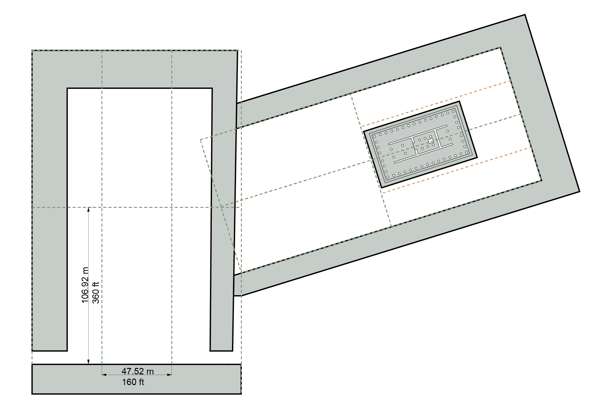
Derivation of the insula dimensions. The agora comprises 6 insulae while 4 insulae, turned on axis with the temple of Artemis, delimit the area of the Artemision enclosure.
Arrayed over the city area, the 360 x 160 ft. block fits remarkably well with the actual state plan. Even if they were used to apportion lots of rural land, quadrature-derived squares seem absent from the plan of the city itself. However, the area between the agora and the west wall of the city can been seen as divided up into four equal rectangular quadrants. Such an arrangement lends itself to division into twelve sections of 8 blocks each. Inscriptions attest that the population of Magnesia was divided into twelve phylae or tribes, each named after a god (Kern 1900, p.212 sv. Phyllen; Szántó, 1906, p.275), in emulation of Plato’s ideal city, also called Magnesia (Plat.Laws 5.745d-e), though it is probable that the cult of the twelve gods was introduced after the original planning of the city (Long, 1987, p. 222) [9]. It is possible, however, that the planners of Magnesia may have been especially motivated to create a geometrically satisfying, even philosophically meaningful layout because of the approach over the hills that would have afforded a ‘bird’s-eye’ view of the city to travelers arriving from Ephesus.

Proposed grid overlaid on actual state plan
Division of the Insulae into House Lots
Due to the lack of excavated houses at Magnesia, the manner in which insulae were divided into houses is a matter of pure speculation. Detailed studies of other cities, however – particularly Priene – allow us to venture a guess as the approximate shape and size of Magnesia’s typical residences. Older Greek cities were typically planned in strips made up of two rows of approx. 50 ft. sided square house lots. This meant that widths of 100 ft. (described as plethra) or 120 ft. (schoinos) were common insula dimensions (Boyd and Jameson, 1981, p.335). In Hippodamian-type systems, however, house lots become more rectangular and insulae wider (Hoepfner and Schwandner, 1986, pp.258-9). Magnesia’s 160 ft. wide block suggests that it was divided into four lots across, in the manner of Piraeus, Priene, and Abdera (Ibid., Abb.255). After subtracting for the streets around 30 ft. (8.91 m) from the short edges and 20 ft. (5.94 m) from the long sides, and supposing a 10 ft.(2.97 m) alley bisecting the block, the two smaller blocks would measure 160 feet by 140 feet. This in turn could be subdivided into eight 80 ft. by 35 ft. blocks, similarly to Abdera (70 ft. by 35 ft.) or Priene (80 ft. by 30 ft.). The remaining area could be split into 18 lots of approximately 247 m² [10]. This hypothetical division would allow Magnesia’s houses to be oriented towards the major east – west roads, corresponding to the flow of traffic through the city. It would also allow for favorable southern sun exposure in the courtyards, as well as accommodating the slope of the land which descended from the foothills of Thorax in the south, to the banks of the Lethaios in the north. This is the pattern observed at Priene. Based on this analog, we may presume a three-part division of the houses’ rectangular shape into a front storeroom structure, a courtyard in the middle, and dwelling at the back of the lot (Ibid., pp.169-176; pp.264-267). However neatly we may conjecturally divide up a typical block, the measurements of individual houses would vary according to the width of the adjacent streets, the more important dimension being the larger 360 ft. by 160 ft. module.

Proposed division of Magnesia's insulae with comparisons (Priene and Abdera after Hoepfner and Schwandner, 1986, p. 259, Abb. 255)
Extent of the City, Number of Blocks and Population
According to a referendum of the second century BC (Bingöl, 2007, p. 138) the number of citizens participating was 4,678. If these constituted one-fourth of the overall population (the rest being women, children, slaves, and non-citizens), and there were approximately 10 inhabitants in each dwelling (Billows, 2005, p.201), then the overall population of Magnesia at this time was around 18,712 and would require 1871 houses on 104 city blocks. Magnesia’s grid of four rectangular quadrants consists of 96 blocks, perhaps indicating that by the time of the referendum, some 150 years since the city’s founding, the city had grown beyond its originally designed capacity (Bingöl, 2007, p.138). Another possibility is that the referendum included citizens who lived within Magnesia’s civic territory on family farmsteads or in villages. . If the city had been intended for 10,000 - 12,000 people, as Bingöl (ibid.) suggests, then 96 insulae would have been more than sufficient. After dividing these 96 blocks into 12 sections, each phyle would have comprised approx. 1,440 people, probably supplemented by the population residing in the local countryside.
An overall conclusion suggested by the results is that Magnesia was founded, as were many Hippodamian cities (Kostof, 1991, p.105), with an eye to future expansion. Space was left between the original four quadrants of the city’s grid and its walls, and the eventual extents of the insulae are not known. There was enough space within the city walls to add additional insulae on both the eastern and western edges of the grid. In Hellenistic times Magnesian rural real estate had become exceptionally expensive, perhaps due to the cultivation of cash crops such as vines, olives and figs (Thonemann, 2011, p.246). For most of antiquity, then, Magnesia was a mid-sized city with prosperous agricultural holdings, larger than mountainous Priene but smaller than the major port city of Ephesus.
The Major Streets
A key characteristic of a city’s main thoroughfare, both in Hellenistic and in Roman times, was that it passed from gate to gate and intersected the main public space of the city, the agora (MacDonald, 1988, p.3; Parrish, 2001, p.11). Clerget documented a gate in Magnesia’s western wall that had all but disappeared by Humann’s time. However, we know from Clerget’s drawings (reproduced in Humann, 1904, p.19, Fig. 4) that the gate’s flanking towers were 8.6m square, and the opening in between is roughly the same dimensions. Therefore, we may presume a width of 30 feet (8.9m) for this street. Magnesia was on the road which connected Ephesus and Tralles, and the route which linked the western gate with the Agora must have been the main thoroughfare of the city. Bingöl (2007, p.136) indicates that the road south of the gymnasium was the city’s main axis, citing the fact that this is still the major route through the site today, albeit 6m above its level in antiquity. However, this is probably a misinterpretation, since the road south of the gymnasium does not pass through the agora. Bingöl appears to interpret a break in the line of the city walls on Humann’s plan (Kern 1900, frontispiece) as indicating the location of a gate. Humann, however (1904, p.20) states that the location of the west gate could not be ascertained by his survey. Furthermore, the foothills of Thorax rise rather sharply to the south of this street, whereas the street passing through the agora is located more centrally in the plain and therefore we may assume within the grid, allowing space for the major buildings, shops, and colonnades that must have flanked it on both sides. Finally, the road south of the agora abuts the Lethaios gymnasium, and it is unlikely that this large building would have been placed directly blocking the major city gate that must have existed at its eastern end.
The northernmost limit of the bath/gymnasium complex, of Roman date, is slightly offset from the street width marked by the gate to the Agora, suggesting that the intervening space could have accommodated a colonnaded walkway in Roman times [11]. Once it passed through the agora, this road must have either turned to the north-east towards Tralles or to the south-east towards Priene. In both cases the road would bypass the Lethaios gymnasium and exit the city through a gate in the wall, connecting with a bridge crossing the Lethaios. In support of this theory, we may cite the evidence found by Bingöl (2007, p.129) for two ancient bridges over the Lethaios, visible both north and south of the modern bridge. The road between Tralles and Priene, passing through the Argavlı strait along the banks of the Lethaios, ran from north to south on the eastern side of Magnesia. The two bridges (and presumably gates) on this side of the city, therefore, would allow access in both directions.

Insulae and streets. Major routes highlighted.
The topography of Magnesia, bounded as it is to the south by mountains and to the north by a river, as well as its position on an east-west route, suggest that there was probably not an important cardo or north-south axis. The streets oriented in the north-south direction must have been narrower and of less importance to the city plan than the east-west avenues, though the positioning of major buildings seems to indicate larger north-south streets every four city blocks. The first of these is the street that ran past the west wall of the agora, and presumably continued into the hills to reach the theatron. Another major street would pass between the east wall of the gymnasium palaestra and the corner of a large Roman building described by Bingol (2007, p.188) as “roughly square in plan with the remains of vaulted foundations at its centre” [12]. Perhaps the most important north-south street is that which bisects the city grid, drawing a line from a door in the city wall in the southern foothills all the way across the Lethaios where it aligns with the Roman temple on the north bank. Finally, according to this scheme a major street would align with the tower that sits above the stadium at the southwest corner of the city wall, flanking the western edge of the stadium.
Notes
[1] Similar problems were recounted by Scherrer (2001, p.80), who made a digital reconstruction of the grid at Ephesus. ↑
[2] The date of Magnesia’s founding is dated by Bingöl (2007, 31) to 386 BC or later. By comparison, the plan for Piraeus, the first ‘Hippodamian’ city, is dated to 451 BC. On the theoretical nature of Hippodamian cities, see Hoepfner and Schwandner (1986). ↑
[3] Common lengths are between 0.295-0.297 for the Attic or Ionic foot, to 0.326 – 0.328 for the Doric foot (Boyd and Jameson, 1981, p. 332). ↑
[4] The existing stadium could be larger than the original one, if for example the struture was enlarged in the Roman period, or the precise positions of the start and finish line (the datum for the measurement) is uncertain. ↑
[5] See also Komboti, Olinthos, Kassope. The ‘strip’ (per strigas) type cities were analyzed by Hoepfner and Schwandner (1986, 250), who differentiate the longer blocks theoretically as well as formally from the later Hippodamian type, calling them streifenstädten (“strip cities”). The blocks were long and of variable length, rather than adhering to a proportional system. R. Martin associates this type with agriculturally-oriented communities where equitable distribution of arable land was of primary importance (Martin, 1973, pp.97-107). ↑
[6] Hoepfer and Schwandner (1986) prioritize the individual house lot as the primary unit upon which town plans were based. While this seems more true of the ‘strip’ type cities of the archaic and early Classical era, the strictness inherent in this granular approach does not seem to do justice to the flexibility of the overall vision that certainly guided many later cities. ↑
[7] Priene: see Hoepfner and Schwandner (1986, pp.150-153); Ephesus: Scherrer (2001, p.86); Piraeus: Hoepfner and Schwandner (1986, pp.13-15, Fig.10). ↑
[8] Thonemann (ibid.) finds similar evidence at Priene. ↑
[9] An inscription from 196 BC (Kern, 1900, no.98) describes a procession in honor of the twelve gods to a temporary altar set up in the agora, in association with the sacrifice of a bull to Zeus Sosipolis (Long 1987, pp. 248 – 251). ↑
[10] By comparison, Priene had lots of ca. 207 m²; Hierapolis ca.208 m²; Miletus ca. 260 m², and Piraeus ca. 242 m². ↑
[11] A short stretch of columns west of the Agora has been identified by Bingöl (2007, 188) as a colonnaded street; however this is more likely to have formed part of a portico or forecourt; the location of the ‘street’ does not coincide with a major thoroughfare; it is rather narrow (5m) and its length only runs about 30m before turning a corner at a right angled. Its other end abuts the massive, arched corner of a Byzantine building of uncertain purpose. For this reason, we might conjecture that the colonnade was erected as a fountain or an extension to this building, and is not one of the major routes of the city. ↑
[12] I was not able to find any additional information about this building, neither its date, plan, nor extent, and therefore have only indicated it generically in the plan. ↑